The most dangerous Erie Canal Dams are hiding in plain sight

With the NY Canal Corporation's Earthen Embankment Integrity Program entering it's third year it's become apparent to many canal neighbors that the work making these embankment safer is still continuing.

There is an Embankment Dam Clearing Guidebook under development by New York Power Authority (NYPA) & New York Canal Corporation (NYCC), that will spell out what dams gets cleared, when they get cleared, how far they get cleared, and what happens after the trees are gone and the grass is growing. 

What else are these Dam Owners responsible for?

Well it seems there are two things at least. They, NYPA & NYCC have to get these "new" dams on the NY State Dam Registry working with NY Dept of Conservation, and also to create something called Emergency Action Plans for their Dams, to share with the communities that live near them. That second task is most likely a joint effort with each Village, Town & City along the Erie Canal from one end to the other.

The Dam Registry is the more important task...

Once these new Earthen Dams are added to the Registry of NY, there should be a follow up activity to understand  EACH dam's Flood Inundation Mapping...otherwise known as the Flood Hazard Zone (FHZ). Based on the topography of the area, and knowing water runs downhill, seeking it's own level, the FHZ can be very concentrated or span miles of lowlands. Residents around these dams need to know if there property is on one of those maps.


This is a Flood Inundation Video of a California Dam that was recently emptied due to safety concerns. Look at how the time lapse shows the extent of the flooding and how far the water travels. 

This is what we should be expecting from the NYS Canal Corporation, Dam Owners


There is a Google Maps Database that anyone can use, to show where each NYS Dam is located. If you click the image below you can view this data yourself through Google Maps by downloading the file.


When you open the file you will see Green Red Blue & Black dots... each is a registered NY State Dam, and if you zoom in you can see location & size information by clicking an individual location dot.


Unchecking a Hazard Zone Type removes dams from the statewide view


Take a look at the dam closest to your neighborhood, just so you understand where it is. Hopefully soon the new Erie Canal Earthen Dams will be added to the  registry list, many of those now changing color from Red & Blue to Green.

It's what NY DAMS that are not shown that is more alarming

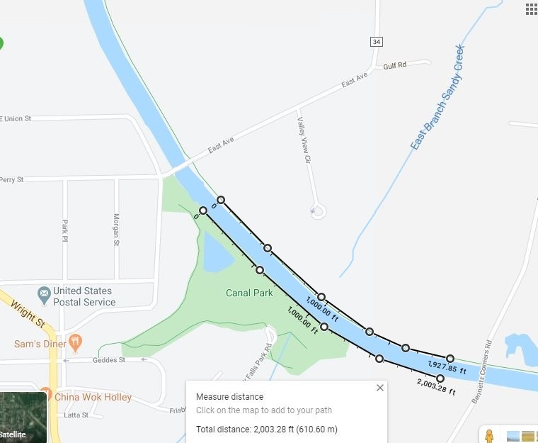
There are many NY dams that are "hidden" still, one of the most alarming is the Holley Falls Dam along the Erie Canal. With this Google Map tool I was able to get some nice images of this area to show why it is CRITICAL that resident along the Erie Canal make sure they know where flood water might flow from. The amount of people in Flood Hazard Zones, that don't know they are in potential danger, is a serious issues now that Erie Canal Dams are being uncovered. Canal Communities need to develop Flood Warning Systems and work with the Canal Corporation on sharing information.

Here are TWO Earthen Canal Dams in Holley... one on the North of the canal that was recently cleared, the other on the South side, higher and covered thick with the wrong vegetation, making this section of earthen dam, unsafe.  By the way, the South Holley Dam has a leaking waterfall coming out of it called Holley Falls. And BOTH dams have a hole in them, a dive culvert or a drainage pipe under the canal to allow Sandy Creek East Branch flow.


Here's what it looks like on Google Earth


What would the Owners Flood Inundation Mapping Show? Maybe something like this.


Maybe it's time that MORE people starting getting involved in their own canal communities to help identify the "hidden" Erie Canal safety issues that still need to be uncovered.

Where is the hidden Erie Canal Dam in your Community?

4 Responses

  1. I AM DOING A DOCUMENTARY ON NESSMUK. AS YOU MAY KNOW HE WAS A VERY STRONG OPPONENT OF DAMS IN THE ADIRONDACKS.
    HE INDICATED THAT WHILE HE STRONGLY SUPPORTED THE WORK OF COLVIN WITH REGARD TO LIMITING DEFORESTATION AND ALSO CREATING A FOREST RESERVE, HE DIFFERED WITH COLVIN’S IDEA THAT SOME DAMS WERE NECESSARY FOR THE ERIE CANAL AND THE
    NY ECONOMY. PLEASE ADVISE ME IF I AM WRONG IN MY UNDERSTANDING.

    • Hello, From our experience, and research, there are no “extra” dams on the Erie Canal or its system…but that is a 1925 Barge Canal statement. Anyone discussing the merits or reasons behind the original ERIE canal would be wasting their time, in my view, that canal no longer exists.

      Maybe a better work would be to look at the overall affects of raising NYS river systems and lowering the canalway that was done to create the canal we have today.

      There are several ADK dams that are needed to supply water for the Canal to operate in the Rome area mainly. Those supply the flow of water to work locks and fill channels that were dug and had no other water supply like the Great Lakes or NY Rivers to fill the ditch.

      Many folks who never flooded in past years, now do more often. The NYSCC has had much of their system reclassified as Flood Zones in 2016, again, why now and can public flooding issues be resolved with making the Barge Canal more Erie-like” and lower the overall water depth to prevent seasonal flooding that canal neighbors now see. The canal was 2/3 of it’s Barge Canal width when it was last worked on in the 1860-70s.. no reason why it could not be narrowed again.

      Less water should be less issues with flooding… and if you call it the Erie Canal, make it look more like it.

      All of the 125 miles of raised embankment dams, that form the Empire Trail berm on top of the dams, are required to retain canal water. Most of that impounding structure is in the western section. About 100 miles of those dams are still not cleared of trees that are making the entire canal system unsafe, right now. and few if any want to discuss that fact. There have only been about 27 miles of Unsafe Canal Earthen Dams repaired so far and until the rest of these dams are cleared, the State of NY has an elevated flood risk.

      Seems like something better to chronicle for posterity, how to fix the canal we have now.

      You can contact us again if you have more questions,

      • Doug,
        It was interesting to meet you, today! I’m still a little skeptical about clear cutting, but you have given me food for thought.
        Have a good weekend,
        Elizabeth

        • Elizabeth,
          Thank you for your comments.

          The real issue is that most people seem to stop at the environmentally sound phrase “trees are good” and never fully understand that it matters WHERE the trees are growing. Trees on a natural hillside add value, Erie Canal Embankments are NOT natural hillsides, Trees on canal embankments are a danger and add zero value to the stability of the embankment. It’s that simple and all these statements are supported by science & engineering best practices.

          Having trees growing on 100 year old earthen dams is a recipe for disaster, and the only thing being done here is a monumental task of repairing these aging structures. In the Brockport area and parts west, the NYS Canal Corporation has repaired about 25 miles of these old canal embankments, and are finishing the “restoration” phase of replacing the dangerous trees they removed, with 1700 approved & acceptable ornamental trees & shrubs that will NOT be a danger to the embankment dam integrity. That new barrier planting is getting rave reviews by all, home owners, canal trail users, and even from some who initially disagreed with the new Canal Embankment Restoration Project called EERP.

          https://www.canals.ny.gov/vegetation/index.html

          Sadly there is STILL a group of people who ONLY see the trees and fail to see the newly cleared, grass covered, safer earthen embankment dam now below these newly planted trees. They do not believe the embankment dams are “real”, nor do they believe the owner’s statements that these earthen structures are highly hazardous and a danger to the surrounding community.

          Go see the pictures for yourself… The earthen dams are real, they are now grass covered as promised, and a privacy barrier is being replaced as needed for canal neighbors. It’s all part of a plan that actual NEIGHBORS of the Erie Canal value highly, but those who are only walking along the Canal Towpath Trail, seem to not fully understand.

          https://ecna.createaforum.com/eerp-phase-3-discussion-board-evergreen-barrier-planting/a-short-walk-on-the-erie-canal-trail-along-a-fully-restored-erie-canal-embankmen/msg1457/?topicseen#msg1457

Leave a comment

TOP